Gpolygon
- Demonstration: Gmaps
- Java API: in release zip
Employment/Purpose
Polygon drawn on the Google Maps per the given (latitude, longitude) points, visible zoom level(0~3), and fill color, etc..
Example
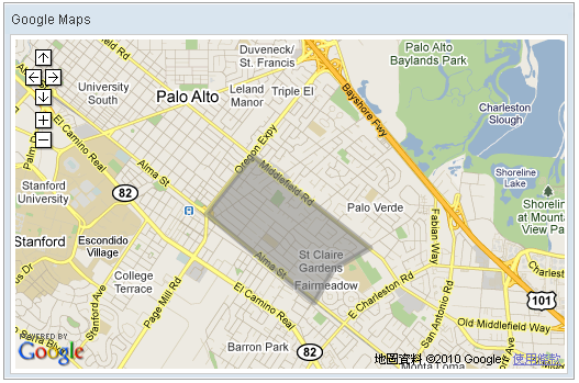
    <script type="text/javascript" content="zk.googleAPIkey='Your-Google-API-Key'"/>
    <gmaps id="mymap" width="500px" height="300px" showSmallCtrl="true">
        <gpolygon path="37.42838786,-122.13998795,
                         37.43561240,-122.13277816,
                         37.42416187,-122.11441040,
                         37.42157162,-122.12007522,
                         37.41734524,-122.12316513,
                         37.42838786,-122.13998795"/>
    </gmaps>
Common Use Cases
Filled Polygon with Colored Outline
Use both fill and outline together to render a polygon with a distinct border and a semi-transparent interior. The outline color is controlled by the inherited color attribute, while the interior uses fillColor and fillOpacity.
<gmaps width="500px" height="300px" showSmallCtrl="true">
    <gpolygon color="#0000CC" fill="true" fillColor="#3399FF" fillOpacity="40"
              outline="true"
              path="37.42838786,-122.13998795,
                    37.43561240,-122.13277816,
                    37.42416187,-122.11441040,
                    37.42838786,-122.13998795"/>
</gmaps>
Outline-Only Polygon (No Fill)
Set fill="false" to draw only the polygon border without shading the interior area.
<gmaps width="500px" height="300px">
    <gpolygon fill="false" outline="true" color="#CC0000"
              path="37.42838786,-122.13998795,
                    37.43561240,-122.13277816,
                    37.42416187,-122.11441040,
                    37.42838786,-122.13998795"/>
</gmaps>
Disable Path Encoding
since 3.3.0
see: Gpolyline - Disable_Path_Encoding
Properties
Outline
Default Value: true
Controls whether the polygon’s border is drawn using the line color set by the color attribute (inherited from Gpolyline). Set to false to suppress the outline entirely, rendering only the fill area.
<gmaps width="500px" height="300px">
    <gpolygon outline="false"
              path="37.42838786,-122.13998795,37.43561240,-122.13277816,37.42416187,-122.11441040"
              fillColor="#0000FF" fillOpacity="40"/>
</gmaps>
Fill
Default Value: true
Controls whether the interior of the polygon is filled with the color specified by fillColor. Set to false to draw only the outline without any interior shading.
<gmaps width="500px" height="300px">
    <gpolygon fill="false"
              path="37.42838786,-122.13998795,37.43561240,-122.13277816,37.42416187,-122.11441040"/>
</gmaps>
FillColor
Default Value: #808080
Sets the fill color of the polygon interior as a hex color string in #RRGGBB format. This color is applied only when fill is true. If set to null, the value resets to the default #808080.
<gmaps width="500px" height="300px">
    <gpolygon fillColor="#3399FF" fillOpacity="60"
              path="37.42838786,-122.13998795,37.43561240,-122.13277816,37.42416187,-122.11441040"/>
</gmaps>
FillOpacity
Default Value: 50
Sets the opacity of the polygon fill as an integer from 0 (fully transparent) to 100 (fully opaque). Values outside this range throw an exception. This property takes effect only when fill is true.
| Value | Meaning |
|---|---|
0 |
Fully transparent — fill is invisible |
1–99 |
Partially transparent |
100 |
Fully opaque — no transparency |
<gmaps width="500px" height="300px">
    <gpolygon fillOpacity="75" fillColor="#FF0000"
              path="37.42838786,-122.13998795,37.43561240,-122.13277816,37.42416187,-122.11441040"/>
</gmaps>
Supported Events
- Inherited Supported Events: Gpolyline
Supported Children
*None