Gmaps
- Demonstration: Gmaps
- Java API: in release zip
Check our Maven repository for the latest version.
Employment/Purpose
Components:
gmaps, ginfo, gmarker, gpolyline, gpolygon, gimage, and gscreen.
A gmaps is a maps component that wraps the famous Google Maps service
that you can control it and embedded it in your ZK web application page
in pure Java. Inside the gmap, you can manipulate your maps and add
contents to the maps to create convenient locality related web
application. You can add ginfo to represent an anchored information
window for the maps. You can add multiple gmarkers to indicate a
special location. You can add gpolyline and gpolygon to indicate a
path or an area. You can also overlay gimage and gscreen to indicate
very special places.
Common Use Cases
- Embed an interactive Google Map in a ZK page with markers, info windows, polylines, and polygons.
- Display location-aware data by binding a
MapModelto the map so pins are added/removed as the viewport changes. - Let users pick a location: listen to
onMapClickto capture the clicked latitude/longitude. - Restrict the visible area with
swlat/swlng/nelat/nelngto fit the map to a known bounding box.
Example
Basic
<gmaps width="500px" height="300px"/>
Init the center of the Map
<gmaps width="500px" height="300px" lat="37.7765" lng="-122.4140"/>
Map Movement and Animation
To move the Maps center smoothly, you can control it by calling Gmaps.panTo() Java method as follows:
<gmaps id="map" width="500px" height="300px"/>
<button label="panTo" onClick="map.panTo(37.4569, -122.1569)"/>
Change the Zoom Level
<gmaps id="map" width="500px" height="300px"/>
<slider maxpos="17" curpos="${map.zoom}" onScroll="map.setZoom(self.curpos)"/>
Adding Controls to the Map
<gmaps width="500px" height="300px" showSmallCtrl="true"/>
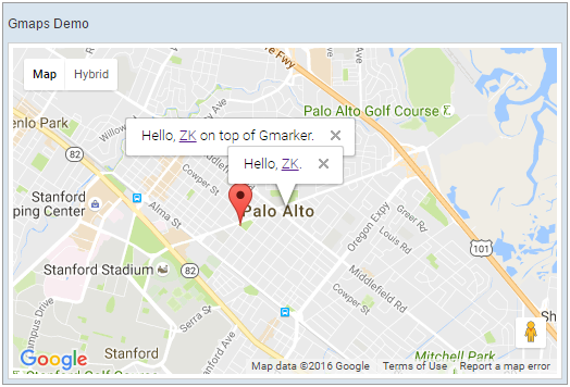
Use with Ginfo and Gmarker
    <!-- you may wish to specify the version of google map API manually for some reason,
        use version="[version]" to do it.
        ex: <gmaps version="3.25" id="mymap" ... /> -->
    <gmaps id="mymap" width="500px" height="300px" showSmallCtrl="true">
        <ginfo id="myinfo" open="true">
            <![CDATA[
                Hello, <a href="http://www.zkoss.org">ZK</a>.
            ]]>
        </ginfo>

        <gmarker id="mymark" lat="37.4410" lng="-122.1490">
            <![CDATA[
                Hello, <a href="http://www.zkoss.org">ZK</a> on top of Gmarker.
            ]]>
        </gmarker>

        <attribute name="onMapClick">
            Gmarker gmarker = event.getGmarker();
            if (gmarker != null) {
                gmarker.setOpen(true);
            }
        </attribute>
    </gmaps>
Setup
This component requires you to include a separate dependency before using it:
		<dependency>
			<groupId>org.zkoss.zkforge</groupId>
			<artifactId>gmapsz</artifactId>
			<version>${gmap.version}</version>
		</dependency>
Check CE repository for available version.
Authentication
Configure in Application Scope
since 4.0.0
In zk.xml
<library-property>
    <name>org.zkoss.gmaps.apiKey</name>
    <value>your_key</value>
</library-property>
<library-property>
    <name>org.zkoss.gmaps.clientId</name>
    <value>your_client_id</value>
</library-property>
API Key
Important: Since 2016 an API Key is mandatory in order to use the gmaps API. The APIKey is defined as a global JS variable as in the examples below. Also check out the Troubleshooting section below. NOTE: You’ll have to upgrade to version 3.0.4 (older versions don’t work anymore)
See Example above.
Client ID
You can specify a client-id at client attribute:
<gmaps client="YOUR_CLIENT_ID"/>
Troubleshooting
Starting from June 2016, an API key is required to use Google Maps APIs. If you are seeing the following error in your JS console, please obtain an API key from Google.
Google Maps API error: MissingKeyMapError
For more information please refer to Google Maps pricing and plans.
Note that ZK GMaps integrates ZK and Google Maps, allowing developers to include Google Maps inside a ZK application easily. Google Maps itself is a 3rd party library and is licensed under its own terms and conditions.
Work with MVVM
3.0.4 already includes the addon.xml below, you don’t need to add
it manually.
since 6.0.0
For work with ZK6 MVVM, it is required to create an addon xml and add the server annotation as follows:
You can download the sample project https://zkgmapsz.googlecode.com/svn/trunk/gmapszTest here
WEB-INF/gmapsz-bind-addon.xml
<?xml version="1.0" encoding="UTF-8"?>
<language-addon>
    <!-- The name of this addon. It must be unique -->
    <addon-name>gmapszbind</addon-name>
    <!-- Specifies what other addon this depends
    <depends></depends>
    -->
    <!-- Which language this addon will be added to -->
    <language-name>xul/html</language-name>
    <!-- Add bind annotation to gmaps -->
    <component>
        <component-name>gmaps</component-name>
        <extends>gmaps</extends>
        <annotation>
            <annotation-name>ZKBIND</annotation-name>
            <property-name>mapType</property-name>
            <attribute>
                <attribute-name>ACCESS</attribute-name>
                <attribute-value>both</attribute-value>
            </attribute>
            <attribute>
                <attribute-name>SAVE_EVENT</attribute-name>
                <attribute-value>onMapTypeChange</attribute-value>
            </attribute>
            <attribute>
                <attribute-name>LOAD_REPLACEMENT</attribute-name>
                <attribute-value>mapType</attribute-value>
            </attribute>
            <attribute>
                <attribute-name>LOAD_TYPE</attribute-name>
                <attribute-value>java.lang.String</attribute-value>
            </attribute>
        </annotation>
        <annotation>
            <annotation-name>ZKBIND</annotation-name>
            <property-name>selectedItem</property-name>
            <attribute>
                <attribute-name>ACCESS</attribute-name>
                <attribute-value>both</attribute-value>
            </attribute>
            <attribute>
                <attribute-name>SAVE_EVENT</attribute-name>
                <attribute-value>onSelect</attribute-value>
            </attribute>
            <attribute>
                <attribute-name>LOAD_REPLACEMENT</attribute-name>
                <attribute-value>selectedItem</attribute-value>
            </attribute>
            <attribute>
                <attribute-name>LOAD_TYPE</attribute-name>
                <attribute-value>org.zkoss.zk.ui.Component</attribute-value>
            </attribute>
        </annotation>
        <annotation>
            <annotation-name>ZKBIND</annotation-name>
            <property-name>lat</property-name>
            <attribute>
                <attribute-name>ACCESS</attribute-name>
                <attribute-value>both</attribute-value>
            </attribute>
            <attribute>
                <attribute-name>SAVE_EVENT</attribute-name>
                <attribute-value>onMapMove</attribute-value>
            </attribute>
        </annotation>
        <annotation>
            <annotation-name>ZKBIND</annotation-name>
            <property-name>lng</property-name>
            <attribute>
                <attribute-name>ACCESS</attribute-name>
                <attribute-value>both</attribute-value>
            </attribute>
            <attribute>
                <attribute-name>SAVE_EVENT</attribute-name>
                <attribute-value>onMapMove</attribute-value>
            </attribute>
        </annotation>
        <annotation>
            <annotation-name>ZKBIND</annotation-name>
            <property-name>zoom</property-name>
            <attribute>
                <attribute-name>ACCESS</attribute-name>
                <attribute-value>both</attribute-value>
            </attribute>
            <attribute>
                <attribute-name>SAVE_EVENT</attribute-name>
                <attribute-value>onMapZoom</attribute-value>
            </attribute>
        </annotation>
        <annotation>
            <annotation-name>ZKBIND</annotation-name>
            <property-name>neLat</property-name>
            <attribute>
                <attribute-name>ACCESS</attribute-name>
                <attribute-value>both</attribute-value>
            </attribute>
            <attribute>
                <attribute-name>SAVE_EVENT</attribute-name>
                <attribute-value>onMapMove</attribute-value>
            </attribute>
        </annotation>
        <annotation>
            <annotation-name>ZKBIND</annotation-name>
            <property-name>neLng</property-name>
            <attribute>
                <attribute-name>ACCESS</attribute-name>
                <attribute-value>both</attribute-value>
            </attribute>
            <attribute>
                <attribute-name>SAVE_EVENT</attribute-name>
                <attribute-value>onMapMove</attribute-value>
            </attribute>
        </annotation>
        <annotation>
            <annotation-name>ZKBIND</annotation-name>
            <property-name>swLat</property-name>
            <attribute>
                <attribute-name>ACCESS</attribute-name>
                <attribute-value>both</attribute-value>
            </attribute>
            <attribute>
                <attribute-name>SAVE_EVENT</attribute-name>
                <attribute-value>onMapMove</attribute-value>
            </attribute>
        </annotation>
        <annotation>
            <annotation-name>ZKBIND</annotation-name>
            <property-name>swLng</property-name>
            <attribute>
                <attribute-name>ACCESS</attribute-name>
                <attribute-value>both</attribute-value>
            </attribute>
            <attribute>
                <attribute-name>SAVE_EVENT</attribute-name>
                <attribute-value>onMapMove</attribute-value>
            </attribute>
        </annotation>
    </component>
</language-addon>
then add it into WEB-INF/zk.xml
<zk>
    <language-config>
        <addon-uri>/WEB-INF/gmapsz-bind-addon.xml</addon-uri>
    </language-config>
</zk>
Properties
BaseDomain
since 2.0
Default Value: null (uses the default Google Maps domain)
Sets the base domain from which to load the Maps API. Useful when you need to load a regional variant of the API — for example, "maps.google.cn" for the Chinese version. When null, the default Google domain is used.
As an alternative for geocoding region bias, prefer region.
<gmaps width="500px" height="300px" baseDomain="maps.google.cn"/>
Center
since 3.0.2
Default Value: 37.4419, -122.1419 (Palo Alto, CA)
Sets the center of the Google Maps as a LatLng object. When using ZUML, set the center via the individual lat and lng attributes instead. This property is typically used in Java or a ViewModel.
The value is a LatLng object constructed in <zscript> or a composer/ViewModel.
<zscript>
    import org.zkoss.gmaps.LatLng;
    LatLng hq = new LatLng(37.4419, -122.1419);
</zscript>
<gmaps width="500px" height="300px" center="${hq}"/>
Channel
since 3.0.2
Default Value: null
Sets the channel parameter of the Google Maps API. The channel is used together with a client ID for usage reporting under Google Maps Premium. It has no effect when using an API key.
<gmaps width="500px" height="300px" client="gme-yourcompany" channel="my-channel"/>
Client
since 3.0.2
Default Value: null
Sets the client ID parameter of the Google Maps API. Use this for Google Maps Premium (Maps for Work) authentication. You should set either an API key (key) or a client ID, not both; if both are set, Google Maps prioritises the API key.
<gmaps width="500px" height="300px" client="gme-yourcompany"/>
ContinuousZoom
since 2.0
Default Value: false
Sets whether to enable continuous (smooth, animated) zoom effects when the user changes the zoom level.
<gmaps width="500px" height="300px" continuousZoom="true"/>
DoubleClickZoom
since 2.0
Default Value: true
Sets whether to enable zooming in/out via a mouse double-click on the map.
<gmaps width="500px" height="300px" doubleClickZoom="false"/>
EnableDragging
since 2.0
Default Value: true
Sets whether the user can drag the map with the mouse. Set to false to lock the map in place.
<gmaps width="500px" height="300px" enableDragging="false"/>
EnableGoogleBar
since 2.0
Default Value: false
Sets whether to show the Google Search Bar on the map.
<gmaps width="500px" height="300px" enableGoogleBar="true"/>
ExtraMapOptions
since 3.1.0
Default Value: empty map
Passes additional Google Maps MapOptions that do not yet have a dedicated ZK attribute (e.g. tilt, fullscreenControl, rotationControl). Options are merged additively into the existing map options; existing options are not removed. Setting an option to null, false, or an empty collection clears it.
Do not use this for options that already have a ZK setter (such as center, zoom, mapTypeId) — doing so results in undefined behaviour.
The value is a Map<String, Object> constructed in <zscript> or a composer/ViewModel.
<zscript>
    import java.util.HashMap;
    Map opts = new HashMap();
    opts.put("tilt", 45);
    opts.put("fullscreenControl", true);
</zscript>
<gmaps width="500px" height="300px" extraMapOptions="${opts}"/>
GmapsApiConfigParam
Default Value: null
Sets an arbitrary additional URL parameter/value on the Google Maps API script request (https://maps.googleapis.com/maps/api/js?...). Use this to pass Google API parameters that are not yet exposed as dedicated ZK attributes. Parameters are stored in an internal map and merged with ZK’s own API parameters.
This property is most useful from Java — in ZUML the dedicated attributes (key, language, libraries, etc.) cover the common cases.
<zscript>
    // Pass a custom parameter not yet covered by ZK gmaps
    map.setGmapsApiConfigParam("callback", "initMap");
</zscript>
<gmaps id="map" width="500px" height="300px"/>
Hybrid
since 2.0
Default Value: true
Sets whether the hybrid map type is available in the map type selector. When false, the hybrid option is removed from the type control. If mapType is currently "hybrid" when this is set to false, the map type falls back to the first available type (normal, satellite, or physical).
<gmaps width="500px" height="300px" hybrid="false"/>
ItemRenderer
since 2.0
Default Value: null (default renderer — assumes each data object is already a Mapitem)
Sets the renderer used to convert data objects from the model into map items (Gmarker, Ginfo, etc.). Only relevant when a MapModel is assigned. Changing the renderer does not automatically re-render the map; re-assign the model to force a refresh.
The value is a MapitemRenderer object constructed in <zscript> or a composer/ViewModel.
<zscript>
    import org.zkoss.gmaps.MapitemRenderer;
    import org.zkoss.gmaps.Mapitem;
    import org.zkoss.gmaps.Gmarker;
    MapitemRenderer myRenderer = new MapitemRenderer() {
        public Mapitem newMapitem(Object data) {
            MyLocation loc = (MyLocation) data;
            Gmarker m = new Gmarker();
            m.setLat(loc.getLat());
            m.setLng(loc.getLng());
            return m;
        }
    };
</zscript>
<gmaps width="500px" height="300px" model="${myModel}" itemRenderer="${myRenderer}"/>
Key
since 3.0.5
Default Value: null
Sets the Google Maps API key. An API key has been mandatory since June 2016. You should set either an API key or a client ID; if both are provided, Google Maps prioritises the API key.
Alternatively, configure the key application-wide via the org.zkoss.gmaps.apiKey library property in zk.xml, or set the global JS variable zk.googleAPIkey on the page.
<gmaps width="500px" height="300px" key="YOUR_API_KEY"/>
Language
since 2.0
Default Value: null (uses the browser’s preferred language)
Sets the preferred language code for map UI text such as control labels, copyright notices, and so on. When set, the specified language overrides the browser’s language preference. Use BCP 47 language codes (e.g. "en", "zh-TW", "fr").
<gmaps width="500px" height="300px" language="zh-TW"/>
Lat
Default Value: 37.4419 (Palo Alto, CA)
Sets the latitude of the map center. Updating lat repositions the map; use together with lng to set a specific location. Both lat and lng are bound via MVVM with the onMapMove save event.
<gmaps width="500px" height="300px" lat="35.6895" lng="139.6917"/>
Libraries
since 3.0.0
Default Value: "geometry,marker"
Sets the comma-separated list of Google Maps API libraries to load alongside the Maps API. The default loads the geometry and marker libraries. Additional libraries such as places, drawing, or visualization can be added as needed.
<gmaps width="500px" height="300px" libraries="geometry,marker,places"/>
Lng
Default Value: -122.1419 (Palo Alto, CA)
Sets the longitude of the map center. Use together with lat to position the map. Both lat and lng are bound via MVVM with the onMapMove save event.
<gmaps width="500px" height="300px" lat="35.6895" lng="139.6917"/>
MapId
Default Value: null
Sets the Map ID required by the Google Maps Advanced Markers API. A Map ID associates the map with a specific style and enables features such as AdvancedMarkerElement. The Map ID must be created in the Google Cloud Console.
<gmaps width="500px" height="300px" key="YOUR_API_KEY" mapId="YOUR_MAP_ID"/>
MapType
Default Value: "normal"
Sets the currently displayed map type. Accepted values:
| Value | Meaning |
|---|---|
normal |
Standard road map (default) |
satellite |
Satellite imagery |
hybrid |
Satellite imagery with road overlay |
physical |
Terrain / physical map |
The corresponding map-type toggle must be enabled (normal, satellite, hybrid, or physical property set to true) for the value to take effect. If the requested type is not enabled, the setter falls back to "normal".
<gmaps width="500px" height="300px" mapType="satellite"/>
Model
since 2.0
Default Value: null
Sets the MapModel that supplies map items (markers, info windows, etc.) to the map. When the model’s visible bounds change (i.e. on onMapMove), it is queried for items within the current viewport and the map is updated accordingly. Assigning the same model again forces a full re-render.
Set to null to disconnect the model; existing model-controlled children are removed.
The value is a MapModel object constructed in <zscript> or a composer/ViewModel.
<zscript>
    import org.zkoss.gmaps.SimpleMapModel;
    // assume myItems is a Collection of Mapitem objects
    SimpleMapModel model = new SimpleMapModel(myItems);
</zscript>
<gmaps width="500px" height="300px" model="${model}"/>
Nelat
since 3.0.2
Returns or sets the north-east latitude of the current map viewport bounds. Setting this value calls fitBounds internally to adjust the visible area. Use together with nelng, swlat, and swlng to define a bounding box.
<gmaps width="500px" height="300px"
    swlat="37.0" swlng="-123.0"
    nelat="38.0" nelng="-121.0"/>
Nelng
since 3.0.2
Returns or sets the north-east longitude of the current map viewport bounds. Setting this value calls fitBounds internally. Use together with nelat, swlat, and swlng.
<gmaps width="500px" height="300px"
    swlat="37.0" swlng="-123.0"
    nelat="38.0" nelng="-121.0"/>
Normal
since 2.0
Default Value: true
Sets whether the normal (road) map type is available in the map type selector. When set to false while mapType is "normal", the map type falls back to the first available alternative.
<gmaps width="500px" height="300px" normal="false" satellite="true" mapType="satellite"/>
Physical
since 2.0
Default Value: true
Sets whether the physical (terrain) map type is available in the map type selector. When set to false while mapType is "physical", the map type falls back to the first available alternative.
<gmaps width="500px" height="300px" physical="true" mapType="physical"/>
Region
since 3.0.5
Default Value: null
Sets the region parameter of the Google Maps API. The region biases geocoding results toward a specific country or territory using a Unicode region subtag (e.g. "US", "GB", "TW"). This is the preferred alternative to baseDomain for geocoding localisation.
<gmaps width="500px" height="300px" region="TW"/>
Satellite
since 2.0
Default Value: false
Sets whether the satellite map type is available in the map type selector. When set to false while mapType is "satellite", the map type falls back to the first available alternative.
<gmaps width="500px" height="300px" satellite="true" mapType="satellite"/>
ScrollWheelZoom
since 2.0
Default Value: true
Sets whether the user can zoom in/out using the mouse scroll wheel.
<gmaps width="500px" height="300px" scrollWheelZoom="false"/>
SelectedItem
Default Value: null
Sets the currently selected map item. The item must be a direct child of this gmaps component and may be a Gmarker, Gpolyline, or Gpolygon. This property is bound via MVVM with the onSelect save event.
The value is a Component (specifically a Mapitem child) obtained at runtime.
<zscript>
    void onSelect() {
        myVM.setSelection(map.getSelectedItem());
    }
</zscript>
<gmaps id="map" width="500px" height="300px">
    <gmarker id="m1" lat="37.44" lng="-122.14"/>
</gmaps>
Sensor
Deprecated since 3.0.5 — the
sensorparameter is no longer required by the Google Maps API. See the SensorNotRequired notice.
since 2.0
Default Value: false
Sets whether the application uses a sensor (such as a GPS locator) to determine the user’s location. This was required by older versions of the Google Maps API but is ignored since version 3.0.5.
<gmaps width="500px" height="300px" sensor="true"/>
ShowLargeCtrl
Default Value: false
Sets whether to show the large pan/zoom navigation control. Enabling the large control automatically disables showSmallCtrl and showZoomCtrl (the three controls are mutually exclusive).
<gmaps width="500px" height="300px" showLargeCtrl="true"/>
ShowOverviewCtrl
since 2.0
Default Value: false
Sets whether to show the overview (mini-map) control in the corner of the map.
<gmaps width="500px" height="300px" showOverviewCtrl="true"/>
ShowPanCtrl
since 3.0.1
Default Value: true
Sets whether to show the pan control on the map.
<gmaps width="500px" height="300px" showPanCtrl="false"/>
ShowScaleCtrl
since 2.0
Default Value: false
Sets whether to show the scale control (map scale bar) on the map.
<gmaps width="500px" height="300px" showScaleCtrl="true"/>
ShowSmallCtrl
Default Value: false
Sets whether to show the small pan/zoom navigation control. Enabling the small control automatically disables showLargeCtrl and showZoomCtrl (the three controls are mutually exclusive).
<gmaps width="500px" height="300px" showSmallCtrl="true"/>
ShowTypeCtrl
Default Value: true
Sets whether to show the map type selector control (the buttons that switch between Normal, Satellite, Hybrid, etc.).
<gmaps width="500px" height="300px" showTypeCtrl="false"/>
ShowZoomCtrl
since 2.0
Default Value: true
Sets whether to show the small zoom-only control (plus/minus buttons). Enabling this control automatically disables showLargeCtrl and showSmallCtrl (the three navigation controls are mutually exclusive).
<gmaps width="500px" height="300px" showZoomCtrl="false"/>
Swlat
since 3.0.2
Returns or sets the south-west latitude of the current map viewport bounds. Setting this value calls fitBounds internally. Use together with swlng, nelat, and nelng to define a bounding box.
<gmaps width="500px" height="300px"
    swlat="37.0" swlng="-123.0"
    nelat="38.0" nelng="-121.0"/>
Swlng
since 3.0.2
Returns or sets the south-west longitude of the current map viewport bounds. Setting this value calls fitBounds internally. Use together with swlat, nelat, and nelng.
<gmaps width="500px" height="300px"
    swlat="37.0" swlng="-123.0"
    nelat="38.0" nelng="-121.0"/>
Version
Default Value: null (resolves to Google’s "weekly" release)
Sets the Google Maps API version to load. When null, the Google Maps JS loader selects the latest stable weekly release. Pin a specific version string (e.g. "weekly", "quarterly", or a numeric version like "3.55") to control upgrade timing.
<!-- Pin to weekly channel explicitly -->
<gmaps width="500px" height="300px" version="weekly"/>
Zoom
Default Value: 13
Sets the zoom level of the map. Valid values range from 0 (fully zoomed out, world view) to 18 (maximum zoom, street level). This property is bound via MVVM with the onMapZoom save event.
<gmaps width="500px" height="300px" zoom="10"/>
Supported Events
| Name | Event Type | Description |
|---|---|---|
onSelect |
org.zkoss.zk.ui.event.SelectEvent | Notifies when the user has selected a new item (can be Ginfo, Gpolyline, or Gpolygon) in the gmaps. |
onInfoChange |
InfoChangeEvent | Notifies when the current open information window has changed (opened/closed). |
onMapDrop |
MapDropEvent | Notifies when a component is dragged and dropped on the gmaps or gmarker component with latitude and longitude information. |
onMapClick onMapRightClick onMapDoubleClick |
MapMouseEvent | Notifies when a mouse action has been applied on the gmaps or gmarker component with latitude and longitude information. |
onMapMove |
MapMoveEvent | Notifies when the view center (latitude, longitude) of the gmaps has been moved. |
onMapTypeChange |
MapTypeChangeEvent | Notifies when the map type of the gmaps has been changed. |
onMapZoom |
MapZoomEvent | Notifies when the zoom level of the gmaps has been changed. |
- Inherited Supported Events: XulElement
Supported Children
Ginfo, Gmarker, Gpolyline, Gpolygon, Gimage, Gscreen, Gcircle